Export Map Layers
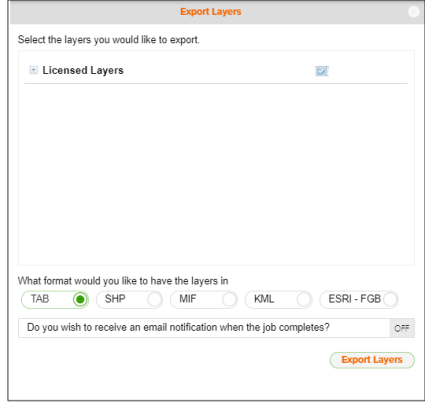
On the Interactive Map Action toolbar, click the Export Layers icon ( ). When the Export Layers pane appears, expand Licensed Layers and then select the layer(s) that you want to export; select your preferred output format; and then click the Export Layers button.
You can export the layers displayed on your Interactive Map in any of the following formats:
- .TAB: The MapInfo® .TAB format is a popular geospatial vector data format for geographic information systems software.
- .SHP: The shapefile format is a popular geospatial vector data format for geographic information system software that is developed and regulated by Esri™.
- .MIF: The MapInfo Interchange Format (MIF) is a map and database exporting file format of the MapInfo software product, which contains information about the projection and the data that is needed to draw the map features (point, line or polygon) on the map.
- .KML: The Keyhole Markup Language (KML) format is a file format used to display geographic data in an Earth browser such as Google Earth™.
- ESRI-FGB: An Esri geodatabase file format that can store, query, and manage both spatial and nonspatial data.
You can also specify to receive an email once the submitted export process job completes.