Retail Target: Export Trade Areas
Easily integrate your GIS site analysis with your third party data visualization tools, as GIS allows you to export your trade areas in Tableau® or Shapefile format.
Export Trade Areas
-
Create you Retail Target Map as usual.
-
Click the Save
 icon.
icon. -
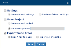
In the Save window deselect Save Project and select Export Trade Areas.
-
Select Export for Tableau or Export as Shapefile.

-
Message displays advising "Creating your trade areas export."
-
File downloads to your browser's default location.
NOTE: Copies of the file may also be found in My Projects, with the default name Trade Area File. Click on the Action icon to download.
-
Tableau files are provided as comma delimited (.csv) files and contain the following column headings:
-
Feature ID
-
LONGITUDE
-
LATITUDE
-
POINTORDER
-
POLYGON NUMBER
-
Site ID
-
Site Name
NOTE: For guidance on how to upload the file into Tableau, refer to their video tutorial on polygon maps.
-
-
The Shapefile exports as a compressed file and contains:
-
.shp — shape format; the feature geometry itself.
-
.shx — shape index format; a positional index of the feature geometry to allow seeking forwards and backwards quickly.
-
.dbf — attribute format; columnar attributes for each shape, in dBase IV format.
-